It's AHRMA (Antique Historic Racing Motorcycle Association) weekend again but yesterday was Thursday, not an official weekend day. I left Frontenac Wed. immediately after getting home from work, the van packed and bikes on the trailer already Tuesday evening. This time that meant they both received a great bath all day Wed. while I was working in St. Paul. From the looks of things, the KLR needs another rainy day....was hoping for a more thorough cleaning. We should be able to agree that what's on there should be looser.
At a Rest Stop just before Tomah, almost half way.....

Yesterday morning, the Road version was unloaded.

While exploring area highlights to build my Routing around, particular markers on www.hmdb.org (I've got the App) caught my eye, those referencing the Military Road in old-time Wisconsin especially so. One thing led to another and soon I was digging into the old records of the Wisconsin Historical Society. From them.....
As much as possible, Center and Doty had taken advantage of natural features and existing Indian trails. Actually, of the 235 miles between the extremities, only about ninety-two miles (39 per cent) traversed new country, the rest closely followed preexisting trails or traces. As noted, the route also had the virtue of not passing over any Indian lands. Another bonus was that the chosen route crossed land superior in quality to that along the west side of Lake Winnebago.
.....Finally on April 1, 1835, Jones, the Adjutant General issued Order No. 20 instructing the Army itself to begin construction. The order laid down the specifications: The road was to be thirty feet wide. Trees less than twelve inches in diameter were to be cut within six inches of the ground and larger ones within a foot, and hollowed out to retain water and hasten their decay. "Substantial bridges" were to be constructed across running streams and those not requiring bridges were to be filled with heavy logs and topped with a hand rail "for the convenience of foot passengers." Causeways made of poles or bundles of brush were to be laid across the road in marshy and wet areas (i.e., corduroyed).
Army soldiers played a big part in the road construction, though various local workers were employed as well. Daily wages, trials and tribulations were recorded and kept track of making a fantastic record of where and what was accomplished. My ability to explore the state can and will be credited to those old boys for getting things started. Statehood came to Wisconsin in 1848, 10 full years before our state of Minnesota became an official State.
This Military Road ran from Green Bay (Lake Michigan - Fort Howard) to Prairie du Chien (Mississippi River - Fort Crawford), the entire width of the yet-to-be-formed State. Roughly 240 miles, the idea that this early route took every advantage of paths already used fascinates me. It's difficult for me to imagine who was able to essentially draw those mostly straight lines in the first place. I'm relatively good at direction, knowing where I am in relation to places around me, etc. but that's only because I pay very close attention to maps that someone else has already charted.
My first stop was only a few blocks from the motel yesterday morning, this right in the city of Fond Du Lac.

Down Hickory St. to leave Fondy, right past Jim's workplace and then SW to near Brandon.

It was quite there today except for the Red Winged Blackbirds that took umbrage at my presence near their nests. I was dived at but never suffered a direct hit.


Isn't it only natural that something else should follow this route that for the most part follows a line?

Just to the south of there is Waupun, a city that again gets fair mention on the hmdb.org website.


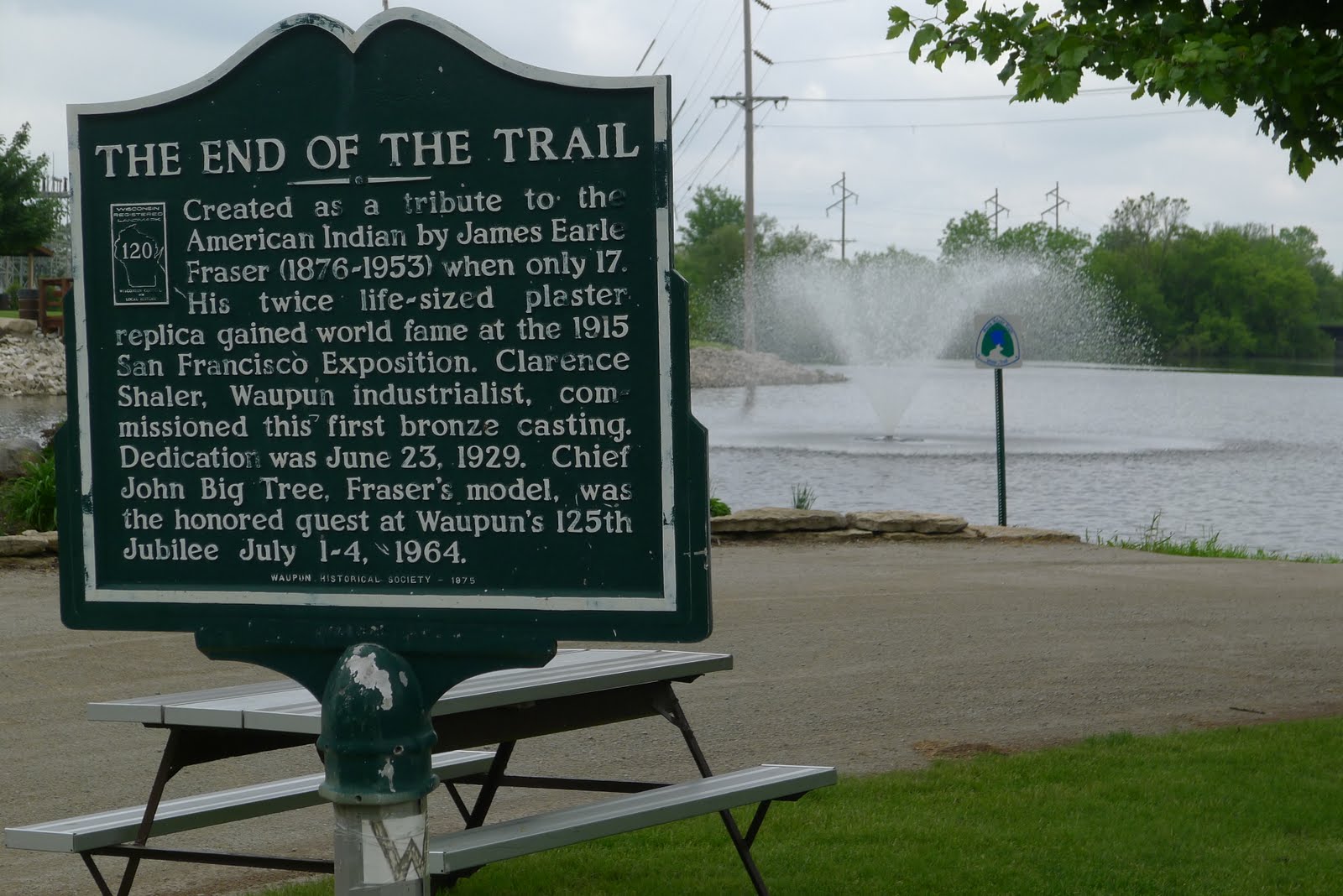
Since the day's theme seems to be "Trails"......

Just east of Waupun is the Horicon Marsh, an extensive waterfowl habitat area. I didn't stop at the Visitor Center this time (have in the past) but you can. I did stop at this Roadside Marker.


Where you've got geese you've got goosey doo........mind your step!


Working my way east, once again in a AHRMA-weekend-Thursday-Counterclockwise loop, I left the valley and climbed back up onto the ridge. I first noticed this roof looking thing along the road and suspected that it was some sort of Produce stand. I guess in some ways it is.


Hilltop Drive looked good on my maps and it was.....


Rolling into Campellsport I had to stop at Loehr's Meat Market, meat sticks and some Very Sharp Cheddar soon in the tankbag.

How could anyone spend time riding in the Kettle Moraine region without stopping at the Hamburger Haus in Dundee?? Now I ask you??

This was an "Everything On It"......

Next door, Sidecar Sue's.......

I stopped at the Ice Age Trail Visitor Center, have been there more than once before but absolutely needed to know if the Curator still had her scooter. I found out that she has "scooters" but she didn't has them yesterday. To this day I'm fascinated by the kames, eskers, moraines and kettles, all the results of glaciation in the area. The Center defines, explains and shows where some remarkable examples can be found.

Continuing east, my goal was one of the very few spots I've found to get free and unobstructed access to the shores of Lake Michigan. The Interstate Highway #43 parallels the west side of the lake and before it was even in sight, the temperature started to drop noticeably. By the time I'd crossed underneath the big road, more degrees were lost and then those last few hundred yards, it felt like I lost 10 all at once.


Fog and mist would come and go.........

Heading west and away from the lake, I swung past the south side of the Road America Complex on Cty J.....

From the outside looking in yesterday......today will be a different story.

I expected to see vintage two wheelers practicing but instead.........4 wheeled vehicles, some of them with large 8 cylinder engines and those 8 cylinder engines were making some real music. For an odd second or two, my heart skipped a beat wondering if my calendar was off. Hopefully it is not.
Back to Fondy, J.P. texted to say that he was almost in town so we gathered together for dinner, both of us trackside in an hour or so.
Another wonderful ride. I assume this was a loop started at the track?
ReplyDeleteThat loop started and ended ~20 miles west of Road America in Fond du Lac, right at the southern end of the large inland Lake Winnebago.
DeleteGreat trip, Coop. And so much history in it. Love the statue!
ReplyDeleteLake Michigan is beautiful. Awesome colour. It reminds me of an ocean...
It's a lovely area, the big lake close by, close enough to influence weather. Thursday's ride turned into a sort of history lesson with some other sights thrown in, hard to believe that was almost a week ago already.
DeleteYou're making me home sick :)
ReplyDeleteJason, I remember that you're more familiar with that area than I am. Always such a fun place to visit and great to return to, so I certainly understand; makes me homesick in a slightly different way.
DeleteWhat a great day tootling around the back roads. I love the rides that have so much history to them.
ReplyDeleteGreat pictures. My favorite are the first of the military Road. Something about the mowed road with the sign I find cool.
Brandy, that spot and old road hit me the same way. It was pleasant in the very best way there Thursday morning. Even stretching my imagination, it's hard to think of all the traffic over the years that followed those paths.
Delete